![](/images/other/stat-length.png)
![Trail Mountain bike La Londe-les-Maures - 2021_08_03_VTTAE Focus massif des Maures de la Londe Babaou - Photo](https://media.geolcdn.com/t/1900/400/ext.pjpeg?maxdim=2&url=https%3A%2F%2Fstatic1.geolcdn.com%2Fsiteimages%2Fupload%2Ffiles%2F1524743154velo.jpg)
2021_08_03_VTTAE Focus massif des Maures de la Londe Babaou
GeGe08
User
![Length](/images/other/stat-length.png)
Length
45 km
![Max alt](https://static1.geolcdn.com/siteimages/upload/files/1508320355ic_sort_altitude_max_24dp.png)
Max alt
461 m
![Uphill gradient](https://static1.geolcdn.com/siteimages/upload/files/1508320355ic_sort_den_pos_24dp.png)
Uphill gradient
1249 m
![Km-Effort](/images/other/stat-length.png)
Km-Effort
62 km
![Min alt](https://static1.geolcdn.com/siteimages/upload/files/1508320355ic_sort_altitude_min_24dp.png)
Min alt
0 m
![Downhill gradient](https://static1.geolcdn.com/siteimages/upload/files/1508320355ic_sort_den_neg_24dp.png)
Downhill gradient
1248 m
![Boucle](https://static1.geolcdn.com/siteimages/upload/files/16400158638029165_repeat_loop_refresh_sync_direction_icon.png)
Boucle
No
Creation date :
2021-08-04 06:55:05.974
Updated on :
2021-08-04 07:00:12.763
![Mountain bike](https://static1.geolcdn.com/sitytour/trail-icons/202.png)
4h18
Difficulty : Very difficult
![Scan this QR Code to open this trail in the SityTrail application](https://capi.geolives.com/qq0zvz2zws4bq2lad0pu/sitytour/trails/2884759/qr.png?size=200)
FREE GPS app for hiking
About
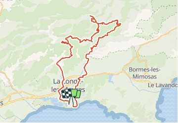
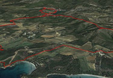
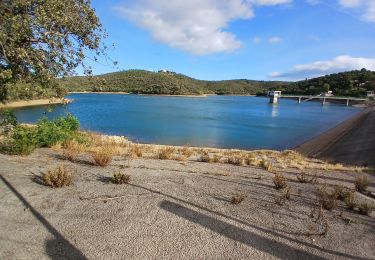
Trail Mountain bike of 45 km to be discovered at Provence-Alpes-Côte d'Azur, Var, La Londe-les-Maures. This trail is proposed by GeGe08.
Description
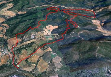
Recherche de petite trace, ce qui explique les détours. la trace de retour, Babaou à La Londe est bien a faire dans le sens inverse, afin de rejoindre Babaou rapidement
Positioning
Country:
France
Region :
Provence-Alpes-Côte d'Azur
Department/Province :
Var
Municipality :
La Londe-les-Maures
Location:
Unknown
Start:(Dec)
Start:(UTM)
275160 ; 4777704 (32T) N.
Comments
Trails nearby
![Trail Walking La Londe-les-Maures - SityTrail - Notre Dame des Maures-12-02-21 - Photo](https://media.geolcdn.com/t/375/260/0b9959c2-5f7c-4a9a-9278-b73c6a0d11e2.jpg&format=jpg&maxdim=2)
![Walking Walking](https://static1.geolcdn.com/sitytour/trail-icons/101.png)
SityTrail - Notre Dame des Maures-12-02-21
Walking
Very difficult
(1)
La Londe-les-Maures,
Provence-Alpes-Côte d'Azur,
Var,
France
![](/images/other/stat-length.png)
14.3 km | 19.8 km-effort
4h 30min
![](https://static1.geolcdn.com/siteimages/upload/files/16400158638029165_repeat_loop_refresh_sync_direction_icon.png)
Yes
![Trail Walking La Londe-les-Maures - la londe des maures- fort de bregancon - Photo](https://media.geolcdn.com/t/375/260/ext.jpg?maxdim=2&url=https%3A%2F%2Fservices.sitytrail.com%2FGeolivesWS%2FDownloadMedia.ashx%3FTrailID%3D174341%26Media%3D20130208144246.jpeg)
![Walking Walking](https://static1.geolcdn.com/sitytour/trail-icons/101.png)
la londe des maures- fort de bregancon
Walking
Medium
(2)
La Londe-les-Maures,
Provence-Alpes-Côte d'Azur,
Var,
France
![](/images/other/stat-length.png)
11.8 km | 13.3 km-effort
3h 46min
![](https://static1.geolcdn.com/siteimages/upload/files/16400158638029165_repeat_loop_refresh_sync_direction_icon.png)
No
![Trail Walking Bormes-les-Mimosas - SityTrail - Barrage du Trapan - Estagnol - Pellegrin - Photo](https://media.geolcdn.com/t/375/260/ebe11e5b-c00f-4172-b479-00c30bf032ed.jpg&format=jpg&maxdim=2)
![Walking Walking](https://static1.geolcdn.com/sitytour/trail-icons/101.png)
SityTrail - Barrage du Trapan - Estagnol - Pellegrin
Walking
Easy
(1)
Bormes-les-Mimosas,
Provence-Alpes-Côte d'Azur,
Var,
France
![](/images/other/stat-length.png)
10.3 km | 12.6 km-effort
4h 0min
![](https://static1.geolcdn.com/siteimages/upload/files/16400158638029165_repeat_loop_refresh_sync_direction_icon.png)
Yes
![Trail Walking Bormes-les-Mimosas - SityTrail - Bormes les Mimosas - Cap Léoube - Photo](https://media.geolcdn.com/t/375/260/313e00c8-6453-4b42-83e0-fd33fc6b49b0.jpg&format=jpg&maxdim=2)
![Walking Walking](https://static1.geolcdn.com/sitytour/trail-icons/101.png)
SityTrail - Bormes les Mimosas - Cap Léoube
Walking
Medium
(1)
Bormes-les-Mimosas,
Provence-Alpes-Côte d'Azur,
Var,
France
![](/images/other/stat-length.png)
17.5 km | 21 km-effort
5h 0min
![](https://static1.geolcdn.com/siteimages/upload/files/16400158638029165_repeat_loop_refresh_sync_direction_icon.png)
Yes
![Trail Walking La Londe-les-Maures - sentier du littoral Lalonde les Maures /Borne les mimosas - Photo](https://media.geolcdn.com/t/375/260/d209c0ef-542c-40b6-8173-c2ec0a0a71bb.jpg&format=jpg&maxdim=2)
![Walking Walking](https://static1.geolcdn.com/sitytour/trail-icons/101.png)
sentier du littoral Lalonde les Maures /Borne les mimosas
Walking
Medium
La Londe-les-Maures,
Provence-Alpes-Côte d'Azur,
Var,
France
![](/images/other/stat-length.png)
23 km | 28 km-effort
7h 43min
![](https://static1.geolcdn.com/siteimages/upload/files/16400158638029165_repeat_loop_refresh_sync_direction_icon.png)
Yes
![Trail Walking La Londe-les-Maures - dolmen de gautabry - Photo](https://media.geolcdn.com/t/375/260/ext.jpg?maxdim=2&url=https%3A%2F%2Fstatic1.geolcdn.com%2Fsiteimages%2Fupload%2Ffiles%2F1553511878bg_sport_marche.png)
![Walking Walking](https://static1.geolcdn.com/sitytour/trail-icons/101.png)
dolmen de gautabry
Walking
Easy
(1)
La Londe-les-Maures,
Provence-Alpes-Côte d'Azur,
Var,
France
![](/images/other/stat-length.png)
10.9 km | 14.4 km-effort
3h 4min
![](https://static1.geolcdn.com/siteimages/upload/files/16400158638029165_repeat_loop_refresh_sync_direction_icon.png)
Yes
![Trail Walking La Londe-les-Maures - Plage de L'Argentière ~ Fort de Brégançon - Photo](https://media.geolcdn.com/t/375/260/c46b2534-bf59-4e8a-b909-995c31cd07e2.jpg&format=jpg&maxdim=2)
![Walking Walking](https://static1.geolcdn.com/sitytour/trail-icons/101.png)
Plage de L'Argentière ~ Fort de Brégançon
Walking
Very difficult
La Londe-les-Maures,
Provence-Alpes-Côte d'Azur,
Var,
France
![](/images/other/stat-length.png)
19.1 km | 22 km-effort
4h 54min
![](https://static1.geolcdn.com/siteimages/upload/files/16400158638029165_repeat_loop_refresh_sync_direction_icon.png)
Yes
![Trail Walking La Londe-les-Maures - Valcros - Photo](https://media.geolcdn.com/t/375/260/6e8bf789-3bce-4b6d-a02e-bc7b394812c5.jpg&format=jpg&maxdim=2)
![Walking Walking](https://static1.geolcdn.com/sitytour/trail-icons/101.png)
Valcros
Walking
Very difficult
La Londe-les-Maures,
Provence-Alpes-Côte d'Azur,
Var,
France
![](/images/other/stat-length.png)
16.2 km | 20 km-effort
6h 7min
![](https://static1.geolcdn.com/siteimages/upload/files/16400158638029165_repeat_loop_refresh_sync_direction_icon.png)
Yes
![Trail Walking Bormes-les-Mimosas - Barrage du Trapan 10-01-2025 - Photo](https://media.geolcdn.com/t/375/260/bbd7ee92-d814-40ba-8b63-839249d00720.jpg&format=jpg&maxdim=2)
![Walking Walking](https://static1.geolcdn.com/sitytour/trail-icons/101.png)
Barrage du Trapan 10-01-2025
Walking
Medium
Bormes-les-Mimosas,
Provence-Alpes-Côte d'Azur,
Var,
France
![](/images/other/stat-length.png)
7 km | 9.1 km-effort
1h 40min
![](https://static1.geolcdn.com/siteimages/upload/files/16400158638029165_repeat_loop_refresh_sync_direction_icon.png)
Yes